
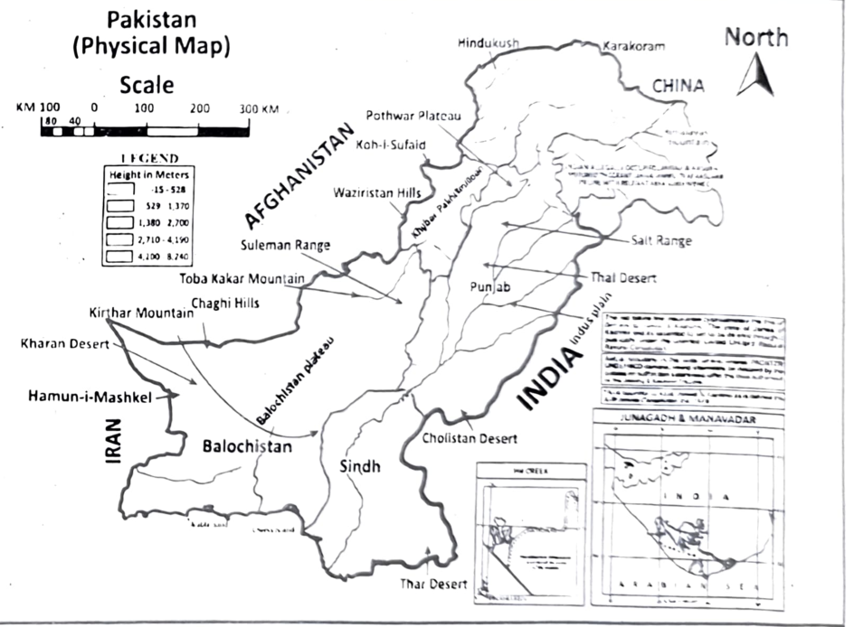
These physical features are important because they directly influence Pakistan's economy, settlements, agriculture, and natural resources.
- Mountains provide glaciers and rivers, which supply water for irrigation and hydroelectric power.
- Plateaus contain minerals and provide land for livestock and some settlements.
- Rivers provide water for irrigation, drinking, agriculture, and hydropower.
- Plains have fertile soil and flat land, making them suitable for agriculture, industries, cities, and dense populations.
Thus, Pakistan's physical features play a major role in determining the distribution of population, economic activities, and natural resources.
Topography:
Topography is the study of the earth surface and the representation of both natural and artificial features of land on a map. The study of topography is fundamental to understanding the Earth's surface features and how they have changed over time.
Main region of natural topography:
The natural topography of Pakistan can be classified into six main regions.
- The Northern Mountains and North Western Mountains
- The Western Mountains
- The Balochistan Plateau
- Potwar Plateau and Salt Range
- The Indus Plain
- Desert Areas
Northern mountains and North western mountains:
This region includes following three mountain ranges.
Himalayas (Altitude about 4000 m):
The Himalayas cover 2500 km from east to West. They include Siwaliks, lesser Himalayas and the central Himalayas. The Siwaliks hills have altitude between 600–1200 meter. While Lesser Himalayas have altitude between 1800–4500 meter.
Tremendous tourist potential:
Himalayas have tremendous tourist potential such as Murree, Galiats such as Ghora Gali, Nathia Gali situated there. The central Himalayas lies between the ranges of Pir Panjal and Karakoram. Most parts of central Himalayas generally located in Kashmir with the highest peak Nanga Parbat having height of about 8126 meters.
Natural vegetation:
The natural topography is characterized with snow peaked mountains, massive glaciers with very rich natural vegetation including tropical evergreen Coniferous forests, deciduous forests and Alpine meadows. Above the tree line, vegetation is in the form of grasses, shrubs and wild flowers.
Hindukush (Altitude about 5000 m):
Hindukush range stretches from central and eastern Afghanistan into northwestern Pakistan and far southeastern Tajikistan. It is the western part of the Hindu Kush Himalayan Region (HKH), and is considered a part of the greater Himalayan Mountain system.
Steep sided narrow valleys:
These mountains have rugged land scape due to steep sided narrow valleys, e. g., Tirch Mir having 7690 m altitude. Due to cold climate, weather is cold and natural vegetation is found in the form of Alpine forests. Plants do not grow above the snow line which starts above 4000 m. At this altitude mountains remain covered with the snow round the year.
The glaciers including Batura and Chianter of the Hindu Kush are a vital source of water for the region, and they also support a number of important economic activities, such as agriculture and hydropower generation.
Strategically important passes:
The Hindu Kush Mountains consist of a number of strategically important passes, including the Shandur Pass, the Shangla Pass, and the Lawarai Pass. These passes connect important population centers and valleys, such as Gilgit, Chitral, Swat, and Peshawar.
Karakoram mountains: (Average Altitude 6000 m)
The Karakoram range consist of a long chain of Rocky Mountains which are generally snowcapped running east to west. The range stretches for 400 kilometers from the Hunza Valley to the Shyok River, with the westernmost part of the range in Pakistan. The Karakoram Mountain range is characterized by narrow and deep valleys, such as the Hunza, Shyok, and Baltoro; towering gorges, such as the Nanga Parbat and Indus Gorges; and vast glaciers, such as the Baltoro, Siachen, and Biafo Glaciers.
Second-highest mountain peak:
K2, the second-highest mountain peak in the world, is also located in the Karakoram. The precipitation at lower elevations is typically in the form of rain. At higher elevations, precipitation is typically in the form of snow.
Natural vegetation:
Natural vegetation at lower elevations is mostly dry and steppe-like, with grasses, shrubs, and scattered trees such as poplar, Juniper and willow. At higher elevations, the vegetation becomes more alpine, with meadows, mosses, and lichens.
The population density:
The population density in the Karakoram Mountain range is low due to the challenging climate and landscape. Most of the population is concentrated in three towns in the disputed Kashmir region of the northern Indian subcontinent Gilgit and Skardu in Gilgit-Baltistan. Most of the people who live in these high-altitude areas are subsistence farmers and pastoralists as they grow crops and raise livestock for their own needs and they trade surplus goods with other communities.
Natural Topography of Pakistan:
Pakistan has a diverse and varied topography, ranging from high mountain systems in the north to plateaus, river valleys, and extensive plains in the south and east. These physical features influence the country’s climate, drainage, agriculture, settlement, and economic activities.
- Mountainous Areas: The northern and north-western regions contain Pakistan’s major mountain ranges, including the Himalaya, Karakoram, and Hindu Kush. These areas have high elevations, steep slopes, deep valleys, glaciers, and snow-covered peaks. The Karakoram contains K2, Pakistan’s highest peak.
- Plateaus: The Balochistan Plateau occupies much of western Pakistan. It consists of rugged terrain, dry valleys, mountain ranges, and arid landscapes. The Potwar Plateau lies in northern Punjab between the Indus and Jhelum rivers and has a gently undulating surface.
- River Systems: The Indus River system forms Pakistan’s major drainage network. The Indus flows from the north towards the Arabian Sea, while major tributaries such as the Jhelum, Chenab, Ravi, and Sutlej flow through Punjab. These rivers provide water for irrigation, agriculture, drinking, and hydropower.
- Plains: The Indus Plain occupies much of eastern and central Pakistan and is divided into the Upper Indus Plain (Punjab Plain) and Lower Indus Plain (Sindh Plain). These plains are mainly formed by alluvial deposits carried by the Indus and its tributaries. Their fertile soils and relatively flat terrain support intensive agriculture and dense settlements.
- Deserts and Arid Regions: Pakistan also contains several arid and semi-arid regions, including the Thar Desert, Cholistan Desert, and Kharan Desert. These areas have low rainfall and sparse vegetation, although irrigation supports agriculture in some parts.
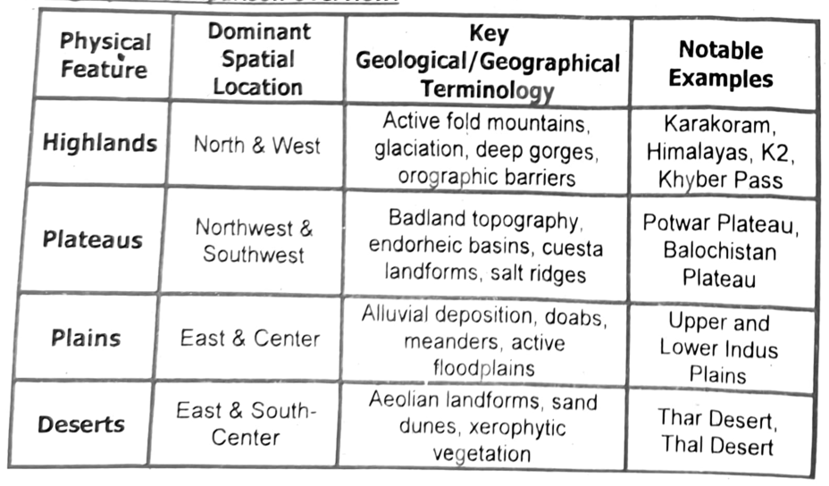
Geographic Comparison Overview:
| Physical Feature | Dominant Spatial Location | Key Geological/Geographical Terminology | Notable Examples |
|---|---|---|---|
| Highlands | North & West | Active fold mountains, glaciation, deep gorges, orographic barriers | Karakoram, Himalayas, K2, Khyber Pass |
| Plateaus | Northwest & Southwest | Badland topography, endorheic basins, cuesta landforms, salt ridges | Potwar Plateau, Balochistan Plateau |
| Plains | East & Center | Alluvial deposition, doabs, meanders, active floodplains | Upper and Lower Indus Plains |
| Deserts | East & South-Center | Aeolian landforms, sand dunes, xerophytic vegetation | Thar Desert, Thal Desert |
Importance of Northern Mountains:
- Source of Water and Hydroelectric Power:
The Northern Mountains are a major source of water for the region, providing drinking water, irrigation water, and hydro power. For example, the Indus River, which provides water for millions of people in Pakistan, originates in the Northern Mountains.
- Climate Regulation:
The Northern Mountains play a role in regulating the climate of the region and the world. For example, the glaciers of the Northern Mountains help to cool the planet.
- Wildlife and Biodiversity:
The Northern Mountains are home to a variety of unique and endangered wildlife species, such as the snow leopard and the Tibetan antelope.
- Protection from Cold Winds:
Mountain peaks provide protection to Pakistan from cold winds of Siberia and Central Asia
- Economic Opportunities:
The Northern Mountains offer a variety of economic opportunities for local communities, such as tourism, agriculture, and forestry. For example, the Northern Mountains of Pakistan are a popular tourist destination for mountaineers and trekkers.
- Raw Materials for Industries:
Northern Mountains provide raw materials to several important industries e. g., chemical industry, pharmaceutical industry, pulp and paper and furniture making industries.
Impact of Earthquake in Northern Areas:
- High Earthquake Risk:
Northern Pakistan, including Kashmir, lies at the collision point of the Eurasian and Indian tectonic plates, making the region highly prone to earthquakes.
- Major Earthquake of 2005:
On October 8, 2005, a powerful earthquake struck Northern Pakistan, causing widespread destruction, particularly in Balakot and Kashmir.
- Loss of Life:
The earthquake caused a massive loss of human-life in the affected areas.
- Destruction of Settlements and Infrastructure:
Many houses, buildings, roads, bridges, and other infrastructure were severely damaged or destroyed. Balakot was almost completely devastated.
Main feature of Western Mountains:
| Name of Mountain Range | Location | Altitude above sea level | Important Features & Passes | Significance |
|---|---|---|---|---|
| Safed Koh | South of the Kabul River | Between 4712 m to 4755 m |
|
|
| Waziristan Hills | Between Kuram and Gomal Rivers | 3513 m |
|
|
| Suleman Range | West of the River Indus in southern Punjab | 3383 m |
|
|
| Kirthar Range | West of the River Indus in Sind | 2174 m |
|
|
Landforms and Human Life in Pakistan:
Pakistan’s different landforms create distinct weather patterns, drainage systems, vegetation, economies, lifestyles, and cultures. These differences can be studied using maps, satellite images, GIS, and other geospatial technologies.
- Mountain Regions:
The northern mountains have cold winters, snowfall, and glaciers. Rivers originate from these mountains, while natural vegetation includes coniferous forests and alpine plants. People mainly depend on livestock, forestry, tourism, and small-scale farming. Mountain communities often have distinct local languages, traditions, clothing, and lifestyles.
- Plateau Regions:
The Balochistan and Potwar Plateaus generally have dry or semi-arid climates. Vegetation is mainly grasses, shrubs, and scattered trees. People depend on livestock, mining, agriculture, and trade. Water is relatively scarce, so settlements are less dense.
- River Plains:
The Indus Plain has relatively flat and fertile land with a network of rivers and canals. The climate is generally hot, with seasonal rainfall. Fertile alluvial soils support crops such as wheat, rice, cotton, and sugarcane. Consequently, the plains have dense populations, large cities, industries, and developed agricultural communities.
- Desert Regions:
Deserts such as the Thar and Cholistan have very low rainfall, high temperatures, and sparse vegetation. People commonly depend on livestock, limited farming, handicrafts, and trade. Settlements are generally scattered because of limited water availability.
- Coastal Regions:
The coastal areas along the Arabian Sea have a generally warm and humid climate. Natural vegetation includes mangroves, while drainage is influenced by coastal rivers and tidal systems. Fishing, shipping, ports, trade, and
Use of Geographical Representations and Geographic Information System:
Physical maps, climate maps, population maps, satellite imagery, and GIS can be used to compare temperature, rainfall, vegetation, rivers, population density, agriculture, and economic activities across different landforms.
Economic Activities and lifestyle in the Western Mountains:
Rugged Landscape and Sparse Vegetation:
The Western Mountain ranges have a rugged landscape and are largely devoid of natural vegetation.
Subsistence and Nomadic Lifestyle:
Most of the population lives in small towns and rural areas and follows a subsistence and nomadic lifestyle.
Low Population Density:
The Western Mountains have a low population density compared with other regions of Pakistan.
Limited Canal Irrigation:
Canal irrigation is not widely possible because of the difficult and mountainous terrain.
Lack of Infrastructure:
The region has limited transport and infrastructure facilities, including commuter trains, paved roads, and air links. However, major centres such as Peshawar and Kohat are connected with other parts of the country by roads and railways.
Untapped Mineral Resources
The Western Mountains have abundant mineral resources, but many remain unexploited because of the rugged terrain and difficult accessibility.
Expand Your Horizon
Read the newspaper clipping and answer the questions given below:
Food security in mountains published in DAWN December 9, 2009
The problem of hunger in mountains is getting worse. Harsh climates and the difficult, often inaccessible, terrain combined with political and social marginality make mountain people vulnerable to food shortages. Indigenous knowledge about local foods and traditional agricultural practices in mountain areas is eroding and agricultural diversity as well as productivity is declining, further increasing the vulnerability of mountain people. Now food prices are soaring worldwide and increased transportation costs to remote mountain areas mean mountain communities are paying that much more for their food, Food and Agriculture Organization (FAO) says.
Q1. How does the harsh climate and difficult terrain in mountains affect the lives of people living there?
Ans: Harsh climates and the difficult, often inaccessible, terrain combined with political and social marginality make mountain people vulnerable to food shortages.
Q2. How is the lack of indigenous knowledge about local foods and traditional agricultural practices affecting the lives of mountain people?
Ans: In addition the indigenous knowledge about local foods and traditional agricultural practices in mountain areas is eroding and agricultural diversity as well as productivity is declining, further increasing the vulnerability of mountain people.
Q3. Suggest some solutions to help mountain communities address the problem of hunger?
Ans: Some potential approaches to addressing these issues include increasing access to food, improving agricultural productivity, strengthening a social safety net, promoting sustainable agriculture, reducing food waste, and addressing the root causes of hunger.
The Balochistan Plateau:
Location:
Balochistan Plateau forms the southwestern half of Pakistan. It is bordered to the north by the Hindu Kush mountains, to the south by the Arabian Sea and to the west by the Iranian border. The plateau is characterized by its high-altitude ranges (600–300 meters) with total area stretching over 347,190 sq km. Balochistan has a dry climate, with less than 250 millimeters (10 inches) of annual rainfall on average.
Distinct topography of Balochistan Plateau:
The distinct topography of Balochistan Plateau is identified as follows:
Basins of North Balochistan:
Between the Toba Kakar and the Suleman ranges, a number of depressions are found which are marked as the Zhob and Loralai basins. Quetta valley is located to the south west of the basin of Loralai.
Basins of Western Balochistan:
The western basins are found between a number of mountain ranges such as Chagai hills, Siahan and central Mekran. Balochistan has inland drainage. The rainwater of the basins drains into the rivers and streams which either absorbed into the ground or forms temporary lakes called Hamuns which contains high salt concentration. The largest Hamun is found in Kharan desert.
Mountain Ranges:
The mountain ranges found in Balochistan Plateau are infertile and devoid of vegetation. However, these ranges contain vast deposits of coal, gold and copper and sulphur. These ranges include:
Central Brahui range Toba Kakar Range Hala range Makran coastal range Siahan Range RasKoh Range Coastal Areas:
Coastal areas of Balochistan Plateau are divided into eastern including Lasbela plain and western extents consisting of Makran coast and its coastal plain is formed by the projection of land into the sea. There are some significant coastal rivers i.e., Hab, Hingol, Porali and Dasht which empty their waters into Arabian sea.
Natural and Economic Resources:
Balochistan plateau is rich in natural resources which are as follows:
Water Resources:
Water resources in Balochistan are limited and unevenly distributed. People face water scarcity all round the year as there is no major source of water. The main sources of water are surface water, ground water in the form of aquifers and springs. The system of Karez helps in irrigation. However, ground water is declining due to over extraction.
Minerals:
Balochistan is rich in mineral wealth which is possibly important but remains an under-developed sector in Balochistan's economy. According to provincial Census report Balochistan 2017, the extraction of thirty-nine out of fifty recorded mineral resources present in the province generates an annual revenue close to Rs. 3.4 billion. The most important minerals are gas, coal, copper, antimony and gold.
Agriculture
Fruit and vegetable production:
Balochistan has two crop seasons: Kharif (summer) and Rabi (winter). Kharif crops include rice, jowar, maize, onion, potato, melons, chilies, tobacco, and sugarcane. Kharif vegetables include lady fingers, tinda, brinjals, bitter gourd, bottle gourd, pumpkin, kharif tomatoes, and cucumber.
Rabi crops include wheat, barley, rapeseed & mustard, cumin, gram, and sunflower. Rabi vegetables include cabbage, carrot, cauliflower, peas, radish, turnip, spinach, beet root, and Rabi tomatoes. Important fruits include almonds, apples, apricots, grapes, peaches, plums, pomegranates, cherries, dates, bananas, mangos, chikoo, papayas, and coconuts.
Fishing:
Balochistan's fishing sector has the potential to grow significantly, but it needs more support infrastructure and services. The important fish are Tuna, Sardinals, Mekerals etc. its coastline is 70% of Pakistan's total coast line, but it only contributes 30% of the country's landed catch. This is due to a lack of supporting infrastructure and services at the ports of Gwadar, Ormara and Pasni, as well as a lack of modern processing facilities. Integrating the development of the coastal highway and the Gwadar port is expected to boost the development of the fishing sector and the local economy.
Livestock:
Balochistan is rich in livestock resources, almost 70 percent population is directly or indirectly involved in livestock rearing activities. Animals such as catties, camels and poultry are traditionally kept for household milk and meat needs. The main consumers of Balochistan's livestock products include the leather, carpet, and pharmaceutical industries.
A poverty alleviation strategy with a focus on livestock development may well target the higher poverty in the province. By investing in infrastructure, services, and training, the government can help livestock farmers to increase their productivity and incomes.
Potential of Pakistan’s Natural Topography for Future Growth and Sustainability:
Pakistan's diverse natural topography—including mountains, plateaus, plains, deserts, rivers, and coastal areas—provides significant opportunities for future leisure, commercial, and economic development. However, sustainable planning is necessary to protect these resources.
Tourism and Leisure Opportunities:
The northern mountains, valleys, lakes, and glaciers provide excellent opportunities for tourism, hiking, mountaineering, skiing, and adventure sports. Areas such as Hunza, Skardu, and Swat can generate employment and income through sustainable tourism.
Agricultural Development:
The fertile Indus Plain has extensive irrigated land and supports crops such as wheat, rice, cotton, and sugarcane. Improving irrigation efficiency, modern farming methods, and water conservation can increase agricultural productivity while reducing pressure on water resources.
Hydropower Potential:
The mountainous regions and rivers provide strong potential for hydroelectric power generation. Developing renewable hydropower can reduce dependence on imported fuels and support long-term energy security.
Mineral and Commercial Resources:
The Balochistan and Potwar plateaus contain valuable mineral and energy resources. Responsible mining can create employment, investment, and industrial development, provided environmental damage is controlled.
Coastal and Maritime Development:
Pakistan’s Arabian Sea coastline offers opportunities for fishing, shipping, tourism, and port-related industries. Coastal development can strengthen international trade and create employment.
Sustainable Development Challenges:
Natural hazards such as floods, droughts, landslides, and water scarcity can threaten development. Deforestation, overgrazing, uncontrolled tourism, and unsustainable mining can also damage ecosystems. Therefore, environmental protection and careful resource management are essential.
Balochistan as a Transit Route to Neighbouring Countries:
Gwadar Port as a Trading Gateway:
Gwadar Port can serve as a hub for interregional transport and trade by providing access to the Arabian Sea for landlocked Afghanistan and Central Asian countries.
Access to Central Asia:
Gwadar has the potential to become an important trade gateway to Central Asia, connecting Pakistan with the wider region.
Land Routes to Neighbouring Countries:
Goods from Gwadar can be transported through land routes to Afghanistan, Tajikistan, Uzbekistan, and Turkmenistan, and further into Central Asia.
Development of Road and Railway Networks:
Road and railway networks are being developed to connect Gwadar with Afghanistan and Iran, making the movement of goods easier.
Border Gateways:
Plans to establish and develop border gateways with Afghanistan and Iran will further facilitate regional trade and transportation.
Balochistan as a Regional Transit Route:
These developments can enable Balochistan to serve as a transit route to Afghanistan and Iran and as a trading gateway to Central Asia.
The Pothwar Plateau & Salt Range:
Location of Pothwar Plateau:
Pothwar plateau and Salt range are located to the south of Islamabad and lying between the river Indus and river Jhelum. It has changing landscape due to constant erosion.
Pothwar Plateau and Salt range have rich deposits of minerals like gypsum, limestone, marble, dolomite coal and oil. A number of oil and gas field are set up in this area such as Attock Oil Refinery. Farming depends on the natural rainfall which is why this area is called Barani (rainfed).
Natural vegetation:
Natural vegetation is consisted of dry temperate forest, with a mix of deciduous and evergreen trees and shrubs.
The Salt Range:
Location of Salt range:
The Salt range is located 160 km from Islamabad. Salt range are parallel ranges with average altitude between 750 to 900 meters and located in Khewra. The area is rich in the mineral deposits such as gypsum, rock salt and limestone. Salt ranges are consisted of broken and faulted land eroded by rivers. It has famous Kallar Kahar lake and Sakesar peak (1,527 m) which is the highest point of the Salt ranges. The main districts of Salt ranges are Jhelum, Mianwali and Chakwal.
Indus plain is formed by the river Indus. It is divided into two plains:
- Upper Indus Plain
- Lower Indus Plain
Some important topographical features and their importance is discussed below:
Active Flood plain:
It is a narrow strip of land with rich alluvial deposits on either side of almost all the river except for the southern half of the river Ravi. Active flood plain is almost regularly flooded every year. The active flood plain of river Ravi is 40 km wide which makes it important for agricultural activities such as crop cultivation, fish farming etc. Other features like meanders and ox-bow lakes are also present in the active flood plain formed by the acts of erosion and deposition.
Old Flood Plain:
An old flood plain is a high, flat area that was once flooded by a river. It is the area that lies between active flood plain and the alluvial terraces. Old floodplains are valuable for agricultural activities, provide food, flood control, habitat, and recreation.
Alluvial Terraces:
Alluvial terraces or bars, are flat and higher grounds that are found at different elevations between the rivers or doabs. They are formed when the river changes its course over time and leaves behind its old floodplain. Alluvial terraces are typically made up of sand, silt, and clay, and they are often very fertile and favour extensive farming.
The prominent alluvial terraces are Nili Bar in Bari Doab, Sandal in Rachna doab and Kirana Bar in Chaj Doab. Doabs attract population because of the availability of flat land for the construction, settlements and other industrial and business activities.
Piedmont Plains or Alluvial Fans:
These plains are formed by the river as soon as it comes out of mountains. These plains are agriculturally productive. Piedmont plains are located at the foothills of Kirthar, Suleman and Siwaliks of Himalayan Mountain ranges.
Tidal Delta:
It is also called Indus delta located to the south of Thatta.
It is a triangular or fan shape with distributes coming out from the main river.
Cuestas:
Cuestas or escarpments are important features of lower Indus Plain. These are limestone ridges gently sloping on one side and steep on the other side. Examples include Rohri Cuesta and Ganjo Takkar in Hyderabad. These cuestas provide firm foundation for the construction of barrages which are used for storage of water for irrigation and fishing purposes.
Doab: Doab refers to a tract of land lying between two rivers. 'Doab' means the land between two streams of a river. The place where two small streams join together and appear in the formation of a big river is called a doab. In other words, Doab separates two rivers.
A piedmont plain is a low-lying area of land that lies at the base of a mountain range.
The term “piedmont” comes from the Italian word “piede,” meaning “foot,” and “mont,” meaning “mountain.” In geography, a piedmont plain refers to a region at the base of a mountain range that has been shaped by the erosion and sedimentation of nearby mountain streams and rivers.
Examples of Piedmont Plains:
- Deccan Plateau in Southern India
- Punjab Plains in Northern India